
This map shows Ontario's location relative to the rest of Canada and the United States.
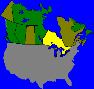
The Great Lakes border on eight separate States, but only on one Province, Ontario. Located in the heart of North America, far from the Oceans, Ontario ironically has one of the longest coastlines.
Lakes and Rivers of Ontario discharge in all direction. Rain that falls here, may end up in the Arctic Ocean, Atlantic, and the Gulf of Mexico.
Canada's largest province falls within two time zones and takes three days to drive across. Within the province most diving regions are an eight hour drive from most border crossings.
From here you can proceed to a more detailed map of the United States and border states, a map of the Great Lakes, or proceed into Ontario for a Geographic search of sites.
SITE INDEX: [MAIN MENU] [MAP INDEX] [American Visitors] [World Wide Visitors] [Canadian Visitors] [Help]
© M. Colautti 1998, 1999