
Using this Engine
| On This Page | [GIS] | [Site Layout] | [Map Index] | [Business Index] | [Map Features] | [Visitors] |
| On This Page | [GIS] | [Site Layout] | [Map Index] | [Business Index] | [Map Features] | [Visitors] |
Tourism is by its very nature geographic, and topical. People visit places, and they do have favourite activities. Currently the bulk of Internet search engines use alphabetical searches or topic searches. Little help is given in coordinating a vacation or journey throughout a region.
The purpose of this engine is to allow you to plan your activities by place. Since a GIS is map based, it is important that you can support graphics on your browser. I have endeavoured to keep the maps simple and compact to avoid long delays in transmission, and no image appears that is not essential to the search. The end result is a suprisingly fast graphical search (our maps are carefully made and average 5-20 Kb each).
If you are familiar with Ontario, you can use this site with the graphics turned off and navigate with the menus if you prefer.
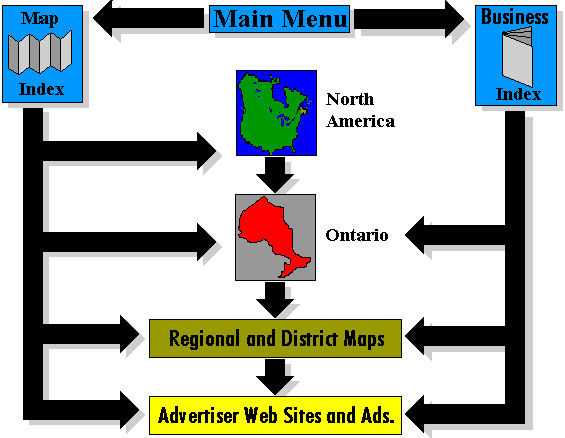
This search engine provides a series of maps in descending order. The highest-order maps begin with a view of North America. From there you can proceed to Ontario, which is further subdivided into twelve tourist regions. Within each region individual attractions, and their associated businesses will appear. The search maps continue to descend, ending in individual street maps. You are not forced to navigate through every map level. At any point you can skip levels and zoom in to areas of specific interest.
The Map Index allows you to to proceed directly to any map within the site from a master table of contents, rather than clicking through numerous pages. The maps are nested. Within each region there may be several maps, which may in turn contain several maps. The index lists them by indenting maps that are contained within a higher one:
The nested levels have been given names. Ministry Regions contain sub-regions called Districts where necessary. These districts are generally named after a prominent or famous physical feature. The names have no relationship to any existing naming scheme.
Districts may be further broken down into Areas, again, where warranted. Areas are also named according to a noteworthy physical feature, such as a river etc.
The final map level are Local maps that usually comprise a single town.
The example below shows that Region 3 contains six Districts. The District Headwaters is subdivided into four Areas. These areas will further break down into separate town listings. Each item on the list is separately clickable and will bring you to that specific map and document
This is essentially a site phone book. Just like the phone book it has a "yellow" and "white" pages. The Alphabetical Index, is similar to the white pages in the Phone Book. The Topic Index is similar to the Yellow Pages, it allows you to select businesses by type, such as Hotel, or Clothing Store.
An additional important feature connects the Business Index to the Maps. Just as phone books are available in local or regional coverage, the business index has numerous levels. Businesses who feel that there services are of local interest only will be placed on a local business index. There are Local, District, Regional and Provincial Business Indexes. The Business Index within each page covers the area visible on that map.

Please note that extensive restructuring of Local and Provincial government has resulted in numerous highways being "downloaded" onto local bodies. Many provincial highways have ceased to exist and have been renumbered as regional or local roads. However, since these highways have been known by locals for decades, and they still appear in most published literature, this site will continue to show the original highway designations. Most regions continue to display both the original highway number and its new local designation on the road signs.
Some towns and cities will have a bi-colour icon. The left background is green, the right side yellow. This style of icon if clicked on the left side leaves the site to an external link. The right side of the icon goes to a link within this site. The rule is easy to remember, left click leaves, right click remains.
Icons locating businesses have a standard appearance, a rectangular yellow window with a colour bar on top. A symbol denoting the company may appear within the box. The symbols are colour coded in three basic categories. Red means EAT, Green means SLEEP, Blue means DO. Generally the red icons indicate restaurants and places where food is available. Hotels, motels, inns etc carry a green bar. Any business that has some form of activity as its primary purpose gets a things to DO colour- blue. More than one colour may appear in the category bar if the business has multiple services. The yellow window may also bear a logo, or identifying symbol of the business.
In some cases you will find sensitive icons on top of sensitive features.--such as a town icon on top of a region. In general, clicking on the sensitive region will bring you to a closeup of that region, with the town icon still appearing on the next map. Clicking on the sensitive icon itself will pull you in quite closer, right into the town or business web page.
Images or maps that have black borders are not clickable. A blue border indicates a sensitve image that may have internal sensitive zones.
Since many of the maps are around water, the colour YELLOW is also used to designate sensitive areas. Also a combination of yellow and blue.
Within an image if the mouse pointer turns into a hand, it is a sensitive spot. Also, read the status bar on your browser. It will show the file name the link will take you to. If you slide across two joining sensitive features, you will see the target name change, and the pointer may flicker between a hand and an arrow, indicating a border was hit.
Read the status bar at the bottom of the browser window, as you slide the mouse over a feature the status bar will tell you where the link is pointing.
These brief pages contain some special information to help visitors from outside of Ontario who wish to travel to Ontario. Basic information on the highways, laws, and currency exchange are provided.
You will note the abscence of a BACK menu option. Since you can descend through the maps in many ways I have no idea which document is 'Back' for you. Use the BACK and FORWARD buttons on your browser instead; they are faster as well.
All material in this site is copyrighted and may not be copied or used without written permission of Colautti Enterprises.
The author of the site has endeavored to keep the information as accurate and up to date as possible, but is not responsible for any errors or ommisions. The user of the site should verify all conditions/information before planning a vacation. NONE OF THE MAPS ARE INTENDED FOR NAVIGATIONAL PURPOSES.
All information in advertisements is provided by the business concerned and the author of this site makes no claim as to its reliability or accuracy.
SITE INDEX: [MAIN MENU] [MAP INDEX] [American Visitors] [World Wide Visitors] [Canadian Visitors]
© M. Colautti 1998, 1999, 2000</>
Visit the new national site CanExplore