
Great Lakes
[MAIN] [Start Here] [Map Index] [Quick Index] [Advertising Here]Hints for Visitors from: [United States] [Off the Continent] [Canada]
Hints for Visitors from: [United States] [Off the Continent] [Canada]

The Great Lakes are the spine of Ontario. They span more than 1200km east to west and the area surrounding the lakes is home to 25% of the population of Canada. The lakes are the largest fresh water bodies on earth. Between them nearly one-fifth of the entire planets fresh water supply is stored. The total surface area of the lakes is 245,000 sq. kilometres, the same size as Great Britain.
While eight U.S. states border on the Great Lakes, Ontario is the only Canadian province to touch their shorelines. Lake Michigan is the only lake solely within the boundaries of the United States. While twenty-five million American's live within the Lake's basin, only eight million Canadian's habitate the immense shoreline.

The lakes are truly immense. The largest, Superior is at the head of the system. From here it's waters and Michigans mingle at Michilimackinac. Lake Huron and Georgian Bay discharge through Lake St. Clair into Erie. Erie's shallow waters pour over Niagara Falls, emptying into Lake Ontario, which empties into the St. Lawrence seaway.
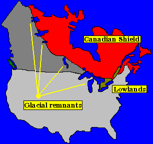
The lakes were formed when the last ice age ended. Immense lakes of water pooled at the edge of the Canadian shield and collected in a gigantic lake system that marks the boundary of the granite of the shield and the surrounding terrain. The lakes in order from the furthest north are: Great Bear Lake, Great Slave Lake, Lake Athabaska, Lake Winnipeg, The Great Lakes.
The Canadian Shield is the central core of the continent. An ancient outcropping of granite it is an eerie landscape of rolling rugged hills. The shield touches the coastline of Lake Superior, Lake Huron, and the outlet of Lake Ontario. South of the shield is the lowlands of the Great Lakes and St. Lawrence valleys. Rolling or flat terrain; there is a distinct contrast between the topography of the southern and northern half of the province.
Each lake has a distinct character to it. Superior being the largest and most northern is very cold. Swimming in the lake is an invigorating experience even in the hottest summers. Lake Huron's temperature is more moderate especially near shore, but again is generally chilly. Lake Erie offers the warmest waters of all the lakes, but can become very tempestuous very rapidly. Drownings have been common off the sand spit parks in the lake due to complacency.

The total shoreline of the great lakes is 17,000 kilometres (10,000 miles). To put this in perspective this distance is close to three times the east/west width of Canada itself.
It would take a year, walking a 10 hour day to pace the shoreline.

The lakes contain 23,000 cubic kilometres of fresh water. This would form a cube of water 30 kilometres (18 miles) on edge were it put all in a single container
Further information on indvidual lakes can be found within these links. These links connect to Dive-Into-The-Net
SITE INDEX: [MAIN MENU] [American Visitors] [World Wide Visitors] [Canadian Visitors] [MAP INDEX]
© M. Colautti 1998