

The annual Monarch Migration at Point Pelee National Park brings the trees to life as they swarm together on the southern most tip of Canada ready to spring southward to their winter harbours in Mexico.
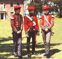
Fort Malden National Historic Park is the southern most military fortification in Canada. It was the home base for Brocks attack on, and capture of Detroit. The park is now host to a comprehensive museum, fortifications and barracks.

The Detroit Skyline as seen from Windsor. The view can be enjoyed from a long strip of river front parks that also furnish an excellent view of the annual Freedom Festival Fireworks that echo and glitter off the imposing skyline.
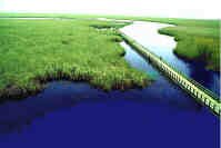
The Marsh Boardwalk in Point Pelee National Park as seen from the viewing tower. This marsh can also be viewed from canoe and offers wonderful birding possibilities. A decade ago this marsh ignited and the flames could be seen from towns many miles away. The marsh returned as vibrant as it ever had been.
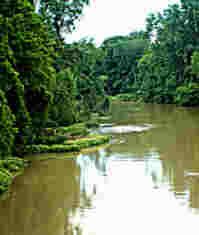
Sydenham River channel winds lazily past the town of Shetland. There are many vistas like this from little known bridges and backroads.

Grand Bend is a popular beach throughout the summer months, located near the Pinery Provincial Park. It is an excellent place for people who enjoy the company and bustle created by swarms of their fellow human beings. The summer heat sees throngs of people basking in the sun and soaking up the throbbing music at night.
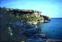
The Bruce Peninsula along the coast of Cyprus Lakes Provincial Park. This 25km section of the trail, to its end in Tobermory, is considered the most difficult section of the trail. It takes about eight hours and passes through spectacular scenery.
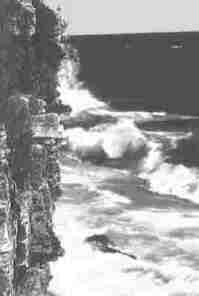
The exposure the coast has can result in spectacular, and dangerous waves. Beware of storms that pass quickly, a few hours behind them can come heavy waves that can catch unsuspecting people by surprise.
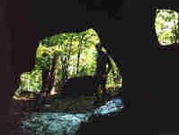
Numerous caves, such as this one on Flowerpot Island are open to visitors. These wave cut caves can be found at the current water level, perched high and dry like this one, or deep below the waves for scuba divers to enjoy; all testament to the fluctuating lake levels over the millenia.
Flowstone forms macabre figures in the darkness. These features are formed when water makes a weak solution from the limestone and as it drips along the walls of the cave, deposits slowly grow over the centuries. As many of the caves along the Niagara Escarpment are wave cut, and are relatively young, these features are still generally small.
Near Caledon, and known locally as the badlands, this area of heavy erosion is an eerie landscape of red soil interspersed with white limestone lines. Formed by poor agricultural practices it is an unusual and frequently photographed site.
Further to the north, Mono Cliffs Provincial park provides year round recreation. A central flat trail runs between two cliffs. This flat trail offers wonderful views, but easy walking. For the more athletic, other trails wind into the hills to join up with the Bruce Trail itself.
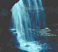
In quiet sun-dappled corners of the Niagara Escarpment hundreds of waterfalls of all sizes are nestled away. Many of them are snuggled away on private lands, many of them are freely available to all. From the tiniest bubbling brooks to the mighty Niagara herself there is nothing as hypnotic as the sound of rushing water.
The rivers of the province were more modestly harnessed in yesteryear. The ruins of many mills enhance the landscape. Many of these structures decay in quiet splendour. Others have been lovingly restored and function as craft shops and restaurants.
For the adventurous backtrail hiking can result in days of solitude deep in the forests or along lonely stretches of coast. Teetering on bridges swung high above gorges offer views like the one below.
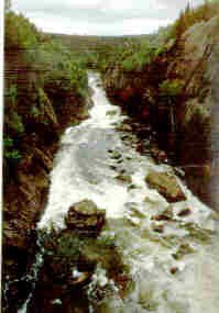
The famed bridge in Pukaskwa National Park is not for the faint-hearted. This bridge swings and jounces at a disastrous height above the torrent below. If you enjoy heights you'll love the view!
Cast your eyes downward occasionally and you may be surprised at the sights you've been missing. Remember all the exciting things you could find in the garden as a child. They are still there, you just need to take the time to look for them again.

Rattlesnake Point conservation area is located on the only stretch of the Niagara Escarpment visible from the 401 highway. As urbanization spreads these oases become ever more important. Rock Climbing is one of the more popular activities here.
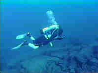
The delights of the provinces environment reach past the shoreline and into the depths of her lakes and rivers. Ontario is home to Canada's only under water park, Fathom Five National Marine Park.
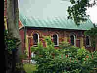
Ruins of a manor house near Wiarton.
Crawford Lake Conservation area. This site is accessible from Rattlesnake Point via a valley trail.
Crawford Lake Conservation area.
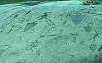
PetroGlyphs Provincial Park displays some rare works of Native Art.
© M. Colautti 1998, 1999, 2000</>
Visit the new national site CanExplore