
 |
||||
|
|
|
|
|
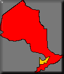
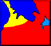
Region 3: LakeLands, District BruceThe thumbnails show the location of the region within the province. Clicking on it raises you to the level shown. |
The Bruce Peninsula cuts a swath across Lake Huron, separating Georgian Bay from the main lake. Essentially a raised ridge of rock it is a unique wind and wave swept peninsula. This rugged but delicate coastline gives the Bruce Trail its name. The terminating marker in Tobermory marks one terminus of the long trail that wanders its way from this remote peninsula into the more populated zones of the province. Numerous parks and endless rugged coastline offer a wonderful playground for young and old alike. The exposed peninsula offers very frigid swimming on rock coast; very few sand beaches exist up here. The character of this landscape is markedly different from the regions to the south.

Towns
|
This feature is often called the ‘spine' of Ontario. It stretches over 2300 km from Niagara Falls, up the Bruce Peninsula where it dives below water to re-emerge on Manitoulin Island, and then on into the Upper Peninsula of Michigan. In places the escarpment towers over 250 metres high.
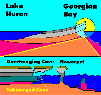
The escarpment is a faulted layer that is higher on the east side than on the west. This gives the Bruce Peninsula two distinct shorelines. The East shore faces the smaller, and calmer Georgian Bay. The cliffs tower over the water, while erosion chips away at the softer layers below creating separate stacks called ‘flower pots' and many sea caves.
The west coast is exposed to the weather of the open lake and its low sloping shore sinks into the lake in a gradual series of steps. The erosion on the elevated east coast has created numerous deep bays, these were ideal choices for the location of settlements, and a map quickly shows that the bulk of the towns are located at the head of the bays on the east side of the peninsula.
A typical stretch of the east coast might offer some indented ledges leading to interior pools. Some of these pools connect through short tunnels back to the outside. Many of the shorter safer ones are routinely explored. Several ledges can be accessed from dry caves from the top. The flower pots do not only stick out above water, but rubble fields below become a giants playground of tumbled pillars and shifted ledges offering plenty of geological diving for the scuba diver. In places it is posible to sit on a ledge and stare below into water over 300 feet below your feet.
From underwater caves and cliffs, boulder fields and petrified forests there are endless possibilities. In the past few years several petrified forests have been discovered and at least one large submerged waterfall that marks some of the past history of the lakes during the Ice Age. If geological diving holds little interest for you there is an excellent collection of shipwrecks scattered along the coast. A good number of them are shore dives, but most will require the use of a boat to reach them.
Currently Fathom Five National Marine Park is Ontario's only underwater park. There are over a dozen vessels to choose from. Depths range from high and dry to 140ft in depth. The bulk of the vessels are located around the tip of the peninsula, but there are several other noteworthy wrecks along the coast. Most of the diveable wrecks are located off the east coast of the peninsula.
The town itself is an Indian Reserve. There is a public use camping ground on the reserve. Spectacular views of the cliffs and a well sheltered beach area whose waters are very wide, but very shallow.
A storybook little hamlet nestled between hills and shore it is on the road to Cabot Head and the scenic lighthouse.
The hospital for the peninsula is located here. As will all towns along the Bruce Peninsula the scenery is wonderful.
This town of 20,000 nestled at the outlet of the Syndenham and Pottawatami rivers was established in 1840. It is a gateway town to the Bruce Peninsula and a significant tourist destination in its own right. The town was the birthplace of Billy Bishop, Canada's greatest WWI flying ace.
Popular vacation spot on the southern Bruce Peninsula. The waters here do not have quite the chill that they do further north along the Peninsula.
The crowning jewel of the Bruce Peninsula, this town teetering on the tip of the Bruce is home to Canada's only underwater park. From here the ferry to Manitoulin Island circulates daily. The town boasts numerous hotels, restaurants, and shops. Perhaps its greatest fame lies underwater in the dozens of shipwrecks that litter the rocky depths.
Deceptively old, the site was used by French Missionaries in the 1600's. It is small town located at the head of Colpoys Bay. The tourism industry is a significant part of the towns economy. Trails lead directly from the town to historic ruins. The towns most famous inhabitant is "Wiarton Willie" a groundhog whose main role is the foreshadowing of spring.
SITE INDEX:
[MAIN MENU] [MAP INDEX] [American Visitors] [World Wide Visitors] [Canadian Visitors] [Help] [Advertise Here]© M. Colautti 1998, 1999, 2000</>
Visit the new national site CanExplore