
Comprising the St. Lawrence Seaway, the Rideau Canal, Ottawa River, numerous lakes and the Eastern End of Lake Ontario this is "Water water everywhere..."
Your journey can take you from the nation's capital to Kingston, a historic port city. Along the St. Lawrence numerous towns and villages dot the sides of the seaway. Inland, you'll find numerous lakes, quarries, rivers and canals awaiting you.
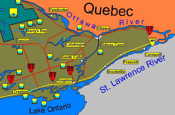
If you are an interested client please use the map and the list nearby to decide if you are best placed within this region, or an adjoining one. Please note, that due to the size of the region it will be further subdivided into several zones with further maps.
This 1300km long river starts far to the northwest at lake Timiskaming. Tributaries flow in from the Laurentian mountains to the north. The river flows towards Ottawa and joins the St. Lawrence at Montreal. Rapids and still lakes punctuate the river along its course. Many of the rivers from the north feature wild water. Two of the southern tributaries, the Petawawa R. and Madawaska R. flow through rugged terrain and are known for their white water.
The river was for several centuries the primary route into the interior of the province. From Montreal fur traders proceeded up the Ottawa River and crossed into the Mattawa R. From there they would descend the French River system and into Georgian Bay. The rich history of the river is often preserved at the bottom of numerous rapids. Unlucky Voyageurs whose canoes capsized in the rough waters have left a trail of axes, muskets and trade goods that still surface today. It is of course illegal for a diver to remove any objects found in the river.
Today those same rapids are challenged by many people in white water rafts, canoes or kayaks, or sometimes in only a life jacket.
Within Ottawa itself the river winds through the town through many rapids and falls. Here the Rideau river joins the Ottawa. The Canal system is used heavily for recreation and in winter is famous for its skating.
Contrary to popular myth Ottawa was not selected to be the capital city by Queen Victoria sticking a pin into the map of Canada. The site was in use centuries before Victoria's time. By the 1830's the construction of the Rideau Canal had spurred the development of "Bytown". The development of the timber trade to Britain furthered the growth of the young community. Sawmills quickly developed powered by the waterfalls in the vicinity. The coming of the rail lines slightly preceded the towns selection as the capital of Canada.
With the collapse of the forest industry, the dominant employer became the federal government. Today the city has over 300,000 citizens. Much of the city is given over to parks along the waterfront. The canal is a significant recreational centre in both winter and summer. In addition to the physical beauty of the city and its surroundings there is an astounding variety of markets, museums, art galleries, and public buildings. In recent years great controversy surrounded the building of and collections of the National Gallery near the parliament buildings. Regardless of these criticisms the building is an impressive cathedral like structure. Nearby monuments of relevance to divers celebrate the riverine explorations in centuries past
Immediately below the parliament buildings lie two wrecks in the waters of the river; the Otter and Minnie. Proceeding downstream there are seven more shipwrecks: The King, Bruce, Resolute, Mansfield, Quinte Queen, Glen Isle, and R.R. Foster #2. Boating traffic and low visibility can pose a hazard at these sites. There are several popular scrounge dives around the city as well.
The St. Lawrence River system along with the Great Lakes penetrates almost four thousand kilometres into the country. The section we are concerned with is known as the International Rapids from Kingston to Montreal. This section was flooded in the 1960's to form the Seaway which allows ocean going vessels access into Lake Ontario. The creation of the Seaway necessitated the evacuation of several towns which are now at the bottom of the river. Some of these sites are currently diveable. These sites are generally considered advanced diving due to the current and visibility.
The stretch of the St. Lawrence from Kingston to Cornwall is too long to do diving along its length in a single day. The diving seems to naturally break up into several zones. The immediate vicinity of Kingston. The Kingston to Prescott corridor, and then the Prescott to Cornwall corridor.
| Wreck | Year Sunk | Length(ft) | Depth(ft) | Special Note |
| Sam Cooke | 1882 | ? | ? | wreckage |
| Henry Daryaw | 1941 | 220 | 55-90 | steel freighter |
| Robert Gaskin | 1889 | 132 | 60 | work barge |
| Keystorm | 1912 | 256 | 20-115 | steel steamer, excellent dive |
| J.B. King &Co. #35 | 1930 | 140 | 80-150 | deep, broken up and under shipping channel |
| Muscallonge | 1936 | 128 | 100 | Wooden tug |
| Lilly Parsons | 1877 | 130 | 40-85 | spectacular, upside down and intact schooner |
| Wreck | Year Sunk | Length(ft) | Depth(ft) | Special Note |
| Conestoga | 1922 | 252 | 10-15 | steam propeller |
| Eastcliffe Hall | 1970 | 253 | 40-70 | very large penetrable freighter |
| Fleur de Marie | 1883 | 100 | 55 | centre board schooner |
| Kitty Hawk | ? | 70 | 20 | intact tug |
| Fred Mercur | 1925 | 232 | 0-50 | wooden propeller, generally intact |
| Rothesay | 1889 | ? | 30 | wooden sidewheeler |
At one point in time this city was a candidate for the provincial capital. It lost out to Toronto, possibly because of a shipwreck! The 'Speedy' was en route to Toronto with a delegation to present a bid to make Kingston the capital. The 'Speedy' struck a formation known as the "Devil's Horseblock" a tower of rock that reared up from the depths of Lake Ontario to within wading depth of the surface. The Speedy struck the formation so hard that it snapped the tower off; both the wreckage of the Speedy and the rock formation were found a few years ago. The loss of the delegation and the dangerous waters around Kingston may have been responsible for the city losing its bid to be the capital.
This city of 60,000 had its European history begin with a French fort in 1673. Its British history began after the American Revolution as a settlement for Loyalists fleeing the U.S. The War of 1812 brought a measure of prosperity for Kingston in the form of shipbuilding. It was here that the "St. Lawrence", a 120 gun ship-of-the-line was built. The largest in the world, the ship saw no combat and after the war served as a floating arcade until some years later it was swept out into the harbour in a storm and sank. It now rests as a pile of scattered lumber on the bottom.
Kingston has become one of the better known dive sites in the province. It competes with Tobermory in being a very accessible, well serviced dive destination. It is a much larger town than Tobermory and so offers a great deal more pursuits beyond diving. The quantity of wrecks is similar to Tobermory's. Many of them are intact and penetrable. The Wolfe Islander ferry was deliberately sunk several years ago and is a very popular intact site. However, the waters are darker and siltier than Tobermory. There is also current and the possibility of overhead traffic that generally makes diving around Kingston more challenging.
| Wreck | Date Sunk | Length(ft) | Depth(ft) | Special Note |
| Aloha | 1917 | 172 | 60 | schooner-barge |
| City of Sheboygan | 1915 | ? | 95 | schooner, well preserved |
| Comet | 1861 | 175 | 85 | Sidewheeler |
| Cornwall | 1930 | 170 | 75 | Scuttled Paddlewheeler |
| Effie May | 1993 | 40 | 55 | Scuttled Scuba Charter Boat |
| George Marsh | 1917 | 135 | 80 | three masted schooner, intact, superior dive |
| Glendora | 1925 | ? | 75 | scuttled steamer |
| Horace Taber | 1922 | ? | 20 | three masted schooner, broken up |
| Mapleglen | 1925 | 240 | 80 | scuttled steamer |
| Manola | 1918 | 290 | 40-80 | bow half of steel steamer |
| Munson | 1880 | na | 110 | dredge |
| Navajo | 1914 | 111 | 10 | steamer, parts above water |
| Prince Regent | 1800's | ? | 20 | war of 1812 vessel |
| St. Lawrence | 1800's | ? | 10 | largest ship-of-the-line ever built, little remains |
| Simla | 1926 | 225 | 90 | scuttled freighter |
| Varuna | 1920 | 75 | 70 | passenger steamer |
| William Jamieson | 1923 | 100 | 80 | schooner, generally intact |
| Wolfe Islander | 1985 | 164 | 40-80 | scuttled car ferry |
Prince Edward County is the large Island between Trenton and Kingston that is Lake Ontario's most prominent feature. As elsewhere with features such as Lake Erie's Long Point, Rondeau or Point Pelee, and Lake Huron's Bruce Peninsula, Prince Edward County forms a natural hazard around which ships had to navigate. The end result is that the ships who were unsuccessful in their bid to round the county are still there....
The county is a popular recreation spot and has several provincial parks. The Bay of Quinte is a sheltered waterway that severs the county from the mainland, and is popular with boaters. The OUC (Ontario Underwater Council) holds their yearly "Treasure Hunt" at Presqu'ile near Trenton.
The Rideau Canal is basically the reason why Ottawa exists. Although the site was used long before the canals construction, the presence of the labour necessary to build the canal ensured a permanent settlement would grow. Originally Ottawa was named Bytown, after Colonel John By of the Royal Engineers who supervised the canals construction. Begun in 1826 the 200km canal linking Ottawa to Kingston required the building of over 50 dams and locks. Truly an engineering marvel of its time, the intent of the canal was to allow military movement from Montreal to Kingston if the St. Lawrence river was blockaded. It had some commercial value, but not enough to keep it viable. Today the canal provides a wealth of recreational pleasures. It should be obvious that diving in the vicinity of a dam or lock, on in an enclosed canal is highly dangerous and should not be done. Even when locks are not in operation water leaks through the doors and can suck a diver against them.
The area surrounding Canada's capital is ironically one of the poorest and remotest regions in the province. The area was completely logged out by the turn of the century. The creation of Algonquin park was an attempt to preserve some of this damaged wilderness. In Petawawa a forestry research centre was started to understand the effects of the lumber industry on the landscape. The eastern end of the province for the most part has never recovered its economic viability.
The scenery is universally beautiful and lakes abound. Within Algonquin park itself there are over 2500 lakes. Most of the lakes are very dark acidic waters. Just driving along the highways you will cross lake after river in what seems to be a landscape that is 50% water. Essentially then the diving is endless. If you just love nature and like diving for fish and rocks and generally underwater scenery you should be happy. However, if you want to dive shipwrecks, the area is pretty much a wilderness. There is but one dive shop out here, and you are a long way from any hospital.
Lake Calabogie has the only dive shop in the region and has a full hotel facility to accomodate guests. Many of the lakes and rivers are controlled by Ontario Hydro. Beneath the waters of Black Donald lake, lies the former town of Black Donald. Divers can visit the empty streets and foundations of former homes. There is a single shipwreck in the interior region, near Barry's Bay.
Rivers such as the Madawaska are popular spots with white water enthusiasts, and therefore only suitable for the experienced current divers. There are current dives, and then there are stick- your- head- in- the- toilet- and -flush dives.
Mazinaw Lake on highway 41 is part of Bon Echo park. A towering cliff rises from the lake challenging climbers. The cliffs continue unseen deep into the depths. This lake is dark and deep, but is becoming a popular dive site. It is well worth the visit with or without your equipment. A ferry and staircase allows even those without the ability to climb to ascend the cliffs and enjoy the scenery.
Numerous provincial parks are scattered throughout the region besides the immense Algonquin. All of them are located on water, so swimming and diving are possible.
SITE INDEX: [MAIN MENU] [MAP INDEX] [QUICK INDEX] [American Visitors] [World Wide Visitors] [Canadian Visitors] [Help]
© M. Colautti 1996-1999, 2000</>
Visit the new national site CanExplore
ontario scuba diving region 6 ottawa kingston ontario scuba diving region 6 ottawa kingston ontario scuba diving region 6 ottawa kingston ontario scuba diving region 6 ottawa kingston ontario scuba diving region 6 ottawa kingston ontario scuba diving region 6 ottawa kingston ontario scuba diving region 6 ottawa kingston